Context
Maritime spaces under the sovereignty or jurisdiction of coastal States are governed by international law, especially maritime law which encompasses all rules relating to the definition and use of maritime spaces. Maritime law is based on the United Nations Convention on the Law of the Sea (UNCLOS), signed on 10 December 1982 at Montego Bay (Jamaica) and ratified by France on 11 April 1996. This convention defines the various maritime spaces that may be claimed by coastal States and the rights and obligations of States with respect to all maritime spaces.
France’s maritime spaces, of a total area of around 10.7 million km², represent the world’s second largest maritime space after that of the United States. Overseas territories give rise to 97% of these spaces. France is a coastal State neighbouring almost all oceans.
As the Treaty of Washington of 1 December 1959 froze all claims on the Antarctic continent, “claimant” States, such as France, cannot have any sovereignty or jurisdiction over waters beyond the Antarctic territory they claim. Submissions for continental shelf extensions are also adjourned. Maritime spaces related to Terre Adélie are therefore not taken into account in France’s current maritime spaces.
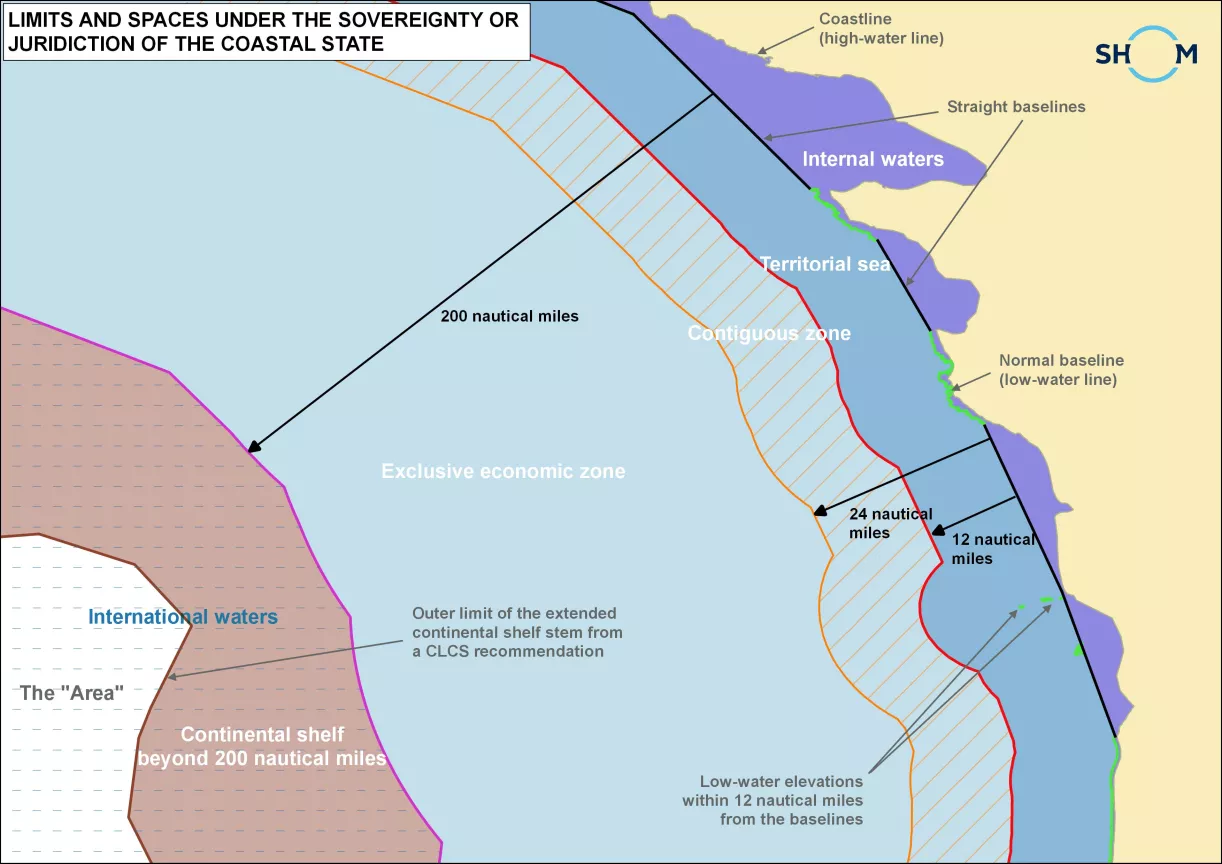
The UNCLOS specifies the various categories of spaces over which States may exercise sovereignty or jurisdiction.
Spaces under sovereignty :
Internal waters
Territorial sea
Spaces under jurisdiction :
Contiguous zone
Exclusive economic zone (EEZ)
Continental shelf
Limits and areas of sovereignty and jurisdiction of the coastal State.
Where the coasts of two States are opposite or adjacent to each other in such a way that their maritime spaces (territorial seas or EEZ) overlap, these States should delimit them by intergovernmental agreement. For example, France delimited its territorial sea with that of the United Kingdom in the Dover Strait, as this strait is less than 24 nautical miles wide. The two States also delimited their respective EEZs in the Channel as it is less than 400 nautical miles wide.
The UNCLOS specifies the method for delimiting territorial seas: application of the equidistance method, except where historic titles or special circumstances apply. However, for delimiting a continental shelf or EEZ, it only specifies that a fair solution should result.
Due to the expanse of its maritime spaces, especially overseas, France shares maritime boundaries with 31 States. Maritime boundary treaties have been concluded with 23 of them, it being understood that a single State may have spaces neighbouring France at several points around the globe. It is for example the case of Australia, in the Pacific and the southern seas, and of the United Kingdom in the Channel, the North Sea, the Atlantic, in the Antilles and in the Pacific.
Beyond the exclusive economic zone, waters are subject to the provisions of the high seas, as defined in Part VII of the UNCLOS. It is an international space of freedom which cannot be claimed by a State under any circumstances. States can extend their continental shelf to beyond more than 200 nautical miles if the Commission on the Limits of the Continental Shelf (CLCS) issues a recommendation recognizing the presence of criteria justifying extension. However, superjacent waters over the extended continental shelf continue to fall within high seas provisions.
Beyond the limits of national jurisdiction is the “Area” which includes the ocean floor and subsoil thereof which are considered to belong to the common heritage of mankind. No State or corporation or natural person may claim as their own any part of the Area or its resources which are managed by the International Seabed Authority in Kingston, Jamaica.